【Report】The eleventh session of the Global Studies Seminar series “Challenges in Global Studies” “The Japanese and Ryukyu: Thinking from Two Maps”
Speaker: WATANABE Miki (Associate Professor at the Department of Interdisciplinary Cultural Studies, Graduate School of Arts and Sciences, the University of Tokyo)
Moderator: TANABE Akio(Department of Interdisciplinary Cultural Studies, the Graduate School of Arts and Sciences)
Discussant: DATE Kiyonobu(Department of Area Studies, the Graduate School of Arts and Sciences)
KOKUBUN Koichiro(Department of Interdisciplinary Cultural Studies, the Graduate School of Arts and Sciences)
To learn more about the Global Studies Seminar series “Challenges in Global Studies,” click here.
【Report】
The eleventh session of the Global Studies Seminar series “Challenges in Global Studies” took place on Tuesday, March 16th, 2021. Professor Miki Watanabe (Associate Professor at the Department of Interdisciplinary Cultural Studies, Graduate School of Arts and Sciences, the University of Tokyo) gave a lecture titled “The Japanese and Ryukyu: Thinking from Two Maps.”
Watanabe began by giving an overview of the history of Ryukyu. Under the tributary system with the Ming Dynasty, Ryukyu served as a subordinate tributary state to China and flourished as a trade base reaching into South East Asia. She then made mention of the commonly held view that the “Invasion of Ryukyu” by the Shimazu clan of the Satsuma domain in the Edo period led to Ryukyu’s “dual subordination” to Japan and China, until in the Meiji period, Ryukyu was formally “annexed” to Japan. Against this view, Watanabe argued that Satsuma’s rule over Ryukyu during the period of “dual subordination” was in fact rather limited, leaving much autonomy to the Ryukyuan people.
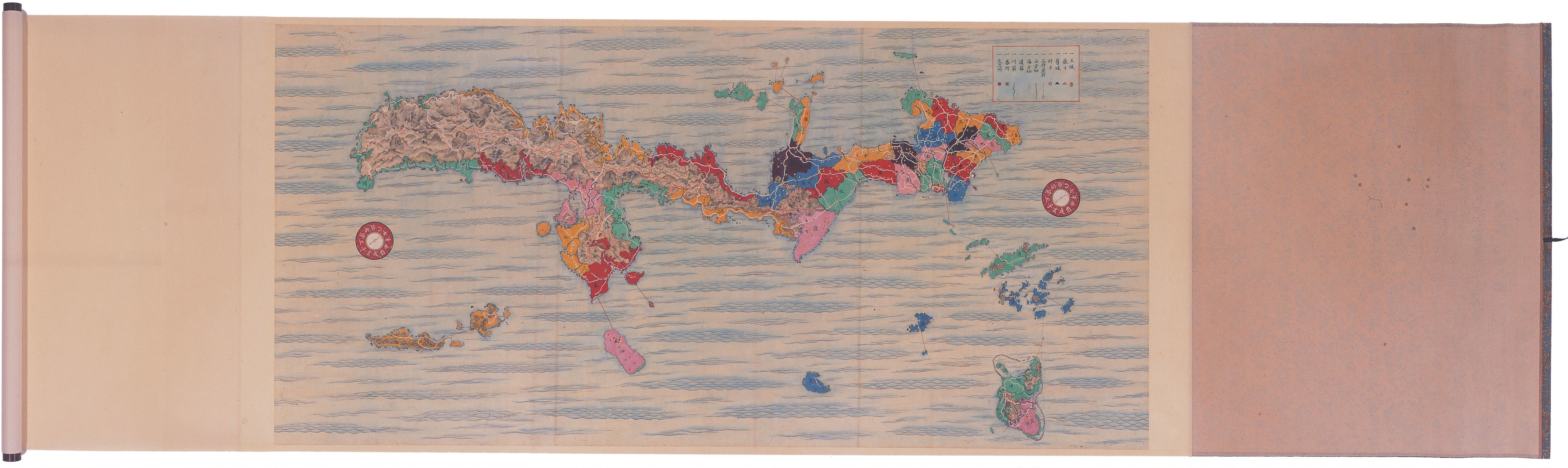
Watanabe then moved on to discuss “Ryūkyūkoku no zu” (「琉球国之図」Map of Ryukyu) included in Haedong Jegukgi (『海東諸国紀』Records of Countries Across the Sea to the East), a text written by Sin Sukju from Korea. While “Ryūkyūkoku no zu” produced in 1471 is believed to be the oldest surviving map of Ryukyu, Watanabe argued, this map was likely based on another map that no longer exists, namely, “Hakata, Satsuma, Ryūkyū aihedatsuru chizu” (「博多・薩摩・琉球相距地図」Map of Hakata, Satsuma, Ryukyu) made by a Hakata merchant named Doan in 1453.
After reviewing these facts, Watanabe turned our attention to “Ryūkyūkoku zu” (「琉球国図」Map of Ryukyu) produced in 1696. “Ryūkyūkoku zu” has not attracted much scholarly attention as it has only recently been rediscovered. However, by comparing place names and sea lanes with those in other maps, Watanabe claimed, we can assume that “Ryūkyūkoku zu” was made not after “Ryūkyūkoku no zu” as it had been thought, but was rather based on the original map produced between the mid-fifteenth and mid-sixteenth century, that is, Doan’s “Hakata, Satsuma, Ryūkyū aihedatsuru chizu.” The map documents finding obtained by Japanese visiting Ryukyu prior to the invasion by the Satsuma domain, thus shedding light upon Ryukyu’s earlier history previously unknown.
This led to a discussion about Takenomori Doetsu, who donated “Ryūkyūkoku zu” to Dazaifu in Kyushu. Takenomori was a vassal of the Kuroda clan of the Fukuoka domain and is known to have dedicated multiple maps to the collection of Dazaifu Tenmangu Shrine, one of which was “Ryūkyūkoku zu.” Takenomori is believed to be one of the members of a group led by Kaibara Ekiken and other intellectuals, who were engaged in sharing and trading books and other documents, actively dedicating them to the Dazaifu Tenmangu Collection.
The above discoveries led to the question as to why “Ryūkyūkoku zu” was produced after a map that was two hundred years-old, and why it was subsequently dedicated to Dazaifu Tenmangu. Since other donated maps depicted contemporary circumstances surrounding Japan, it is likely that Takenomori regarded the original map by Doan to retain relative faithfulness to the situation of Ryukyu at the time. With travel restrictions in place under the rule of the Satsuma domain, Takenomori did not have access to accurate information on the contemporary state of Ryukyu. This is probably why for Takenomori, even a very old map like Doan’s served as a valuable source of information available at the time.
One of the discussants, Kiyonobu Date asked about (1) the attempts by the Ryukyuan people to make maps themselves, (2) the relationship between map making and its dedication to shrines, and (3) perceptions of the self and other as seen in maps. The other discussant, Koichiro Kokubun asked about (1) the world map donated by Takenomori and (2) the relationship between maps and governance. Moderator Akio Tanabe further asked about (1) the real and the fictional as depicted in maps and (2) the exact way in which Ryukyu was represented in maps. In response to these questions, Watanabe stressed the need for and promised further investigation into the social significance of map representations and their dedications to shrines. The session was concluded with a lively discussion, including questions raised from the floor concerning (1) the treatment of castaways and (2) the understanding of national borders on the part of the Ryukyuan people.
【YOKOYAMA Yuta (Graduate Student at the Graduate School of Arts and Sciences)】
【translated by ELLIS Naomi (Ph.D. Student at the University of California, Los Angeles)】